- StartCapuliyoc ≈ 2,911 m, three to four hours' drive from Cusco via Cachora
- Lowest pointPlaya Rosalina on the Apurímac 1,478 m, suspension bridge
- Highest pointChoquequirao 3,050 m; no pass
- CampsChiquisca (≈ 1,900 m), Santa Rosa (2,230 m) or Playa (1,478 m), Marampata (2,911 m) – depending on product
- Distance≈ 60 km out and back; ≈ 3,000 m of ascent in total
The profile: a V, twice
The route is a V with Choquequirao at the top of the second arm. Day 1 goes down: four hours of switchbacks from Capuliyoc to Chiquisca, with the TreXperience versions on to the river. Day 2 goes up: suspension bridge, Santa Rosa, three to four hours of zigzags to Marampata, with TreXperience's 5-day version on to the site. Day 3 is the site. Then the same V back: down to Santa Rosa and the river, up to Chiquisca; on the last morning the 1,100 m to Capuliyoc.
What the profile hides: the sun. The canyon lies at 1,500 to 2,500 m, it is hot, and the switchbacks to Marampata have no shade. Operators start the climbs early; dawdle and you climb in the midday heat. Three litres of water on the ascent day is normal.
Itineraries of the three products
From the Viator product data, shortened. The camps differ: Salkantay Trekking sleeps at Chiquisca and Marampata, TreXperience at the Playa or Santa Rosa and up by the site. TreXperience's 4-day version carries the same text for days 1 and 2; we filled day 2 from the 5-day version and mark it as such.
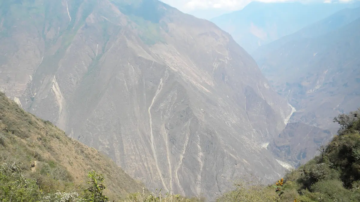
First you descend 1,400 m. That's the easy part.
From Capuliyoc on the first morning you see it all at once: the canyon, the river far below, and opposite the slope that holds Choquequirao. Then hours of switchbacks downhill, sun on your back, knees on your mind.
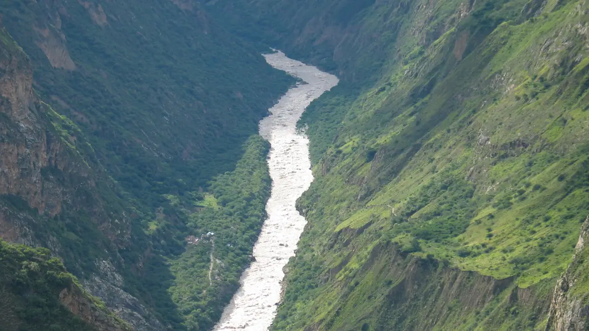
The lowest point. From here, only up.
A suspension bridge over a river that further down becomes the Amazon. It is hot here, there are sandflies, and 1,500 m of ascent lie ahead to camp. Salkantay Trekking schedules a swim stop here on day four.
Three hours of switchbacks. Then evening light in the canyon.
The day that sets Choquequirao apart from the Salkantay: no altitude above 3,100 m, but a climb with no rest and no shade. Marampata is a hamlet of a few families running the camps.
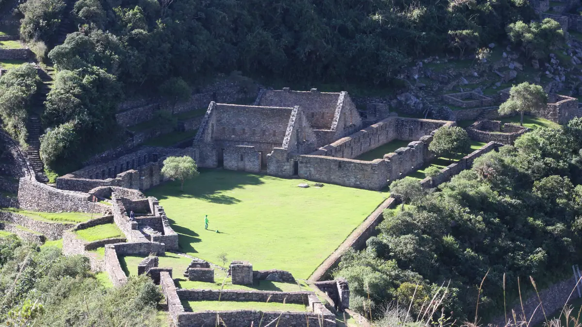
An Inca city, and maybe ten other people.
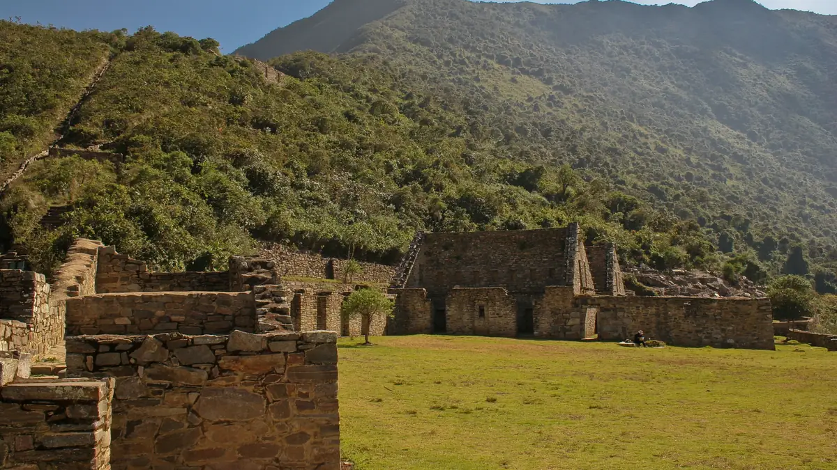
Only part of the site is excavated. Main plaza, residential sector, the llama terraces with white stone figures in the slope. On the 5-day versions you have the whole day; on four days, an afternoon and a morning.
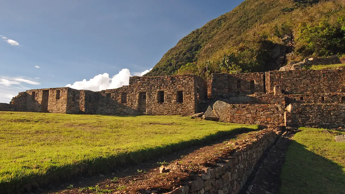
No train, no buses. Just wind over the terraces.
This is the difference to Machu Picchu that no photo shows: it goes quiet. Whoever can stay until the sun sinks into the canyon understands why the route is chosen despite the effort.
One more 1,100 m climb at the end. Start early.
The last day starts before the sun because the slope bakes from ten o'clock. Lunch waits at the top in Capuliyoc, then farewell to the crew; Salkantay Trekking then drives to the Saywite stone and the Conoc hot springs.
The route in stages: altitudes and itineraries from the operator data, photos illustrate the places. The boxes show where the four compared offers differ at the same spot.
Salkantay Trekking · Choquequirao 5 days 5 days · 4 nights
Pickup 4:30 am, breakfast at Cachora with views of Salkantay and Humantay, meet cook and muleteers at Capuliyoc (2,911 m), three-hour descent to Chiquisca among fruit crops.
☾ Camp Chiquisca ≈ 1.900 mOne hour down to Playa Rosalina (1,478 m), suspension bridge, then the hardest part: lunch at Santa Rosa, three hours of switchbacks up to Marampata overlooking the canyon.
☾ Camp Marampata 2.911 mThe whole day at the site (3,050 m), an hour from camp: main plaza, terraces, llama terraces, guided tour. Back to camp in the evening.
☾ Camp MarampataTwo hours down to Santa Rosa for lunch, swim in the Apurímac at Playa Rosalina, climb to Chiquisca, evening with a local family.
☾ Camp ChiquiscaEarly start because of the sun, four hours up to Capuliyoc, farewell to the crew, Saywite monolith, Conoc hot springs, lunch, arrival in Cusco around 6 pm.
TreXperience · Choquequirao 4 days 4 days · 3 nights
Pickup 4:30–5 am, breakfast at Capuliyoc (2,911 m) around 8:30 am, four-hour descent to Chiquisca (1,893 m) for lunch, two more hours down to Santa Rosa.
☾ Camp Santa Rosa 1.478 mClimb to Marampata and on to the site (operator's day text identical to day 1 – confirm the schedule before booking).
☾ Camp bei der AnlageSunrise at the site, three hours down to Santa Rosa for lunch, two more hours down and two up to Chiquisca.
☾ Camp Chiquisca 1.800 mFour hours up to Capuliyoc, lunch, farewell to the crew, drive to Cusco, arrival around 5 pm.
TreXperience · Choquequirao 5 days 5 days · 4 nights
Pickup 4:30 am, breakfast at Capuliyoc, four hours down to Chiquisca (1,893 m), two more down to the riverside camp.
☾ Camp Playa 1.478 mSuspension bridge over the Apurímac, four hours up to Marampata (2,911 m), lunch, two more hours to the site (3,030 m).
☾ Camp bei der Anlage ≈ 2.900 mSunrise, then the whole day at the site with the guide.
☾ Camp bei der AnlageThree hours down to Santa Rosa (2,230 m) for lunch, two down, two up to Chiquisca.
☾ Camp Chiquisca 1.800 mFour hours up to Capuliyoc, lunch, drive back, arrival in Cusco around 5 pm.
Stops and walking times from the operator's Viator product data, edited for length. Maps and figures illustrate the route and are not for navigation.
The site: what you can see in a day
Choquequirao sits on a ridge above the Apurímac, around 1,800 hectares, of which an estimated third is excavated. From Marampata camp it is an hour to the main plaza. To see: the main plaza with temple and residential buildings, the upper plaza, the terraces, the water system, and – an hour's descent and climb back – the llama terraces with white stone figures in the slope, the best-known motif. If you want the llamas, you need the whole day; the 4-day version usually only stretches to the main plaza.
When to go: dry season for the switchbacks
April to October is dry; May to August the safest. In the canyon it is hot by day all year, cool at night in Marampata. November to March it rains, the switchbacks get slippery, the river rises; the trek is possible, but camps and paths suffer. Choquequirao has no closure.
Questions about the route
How hard is the Choquequirao trek?
Demanding because of the vertical, not the altitude. 1,500 m of continuous ascent in the heat, twice. Trained hikers manage it; mules carry the gear, and a riding animal for emergencies is available with most operators for a fee.
Is there water along the way?
The camps and the hamlets of Chiquisca, Santa Rosa and Marampata have small shops selling water. Salkantay Trekking lists purified water in its inclusions, TreXperience does not. A filter or tablets make sense anyway.
Can you do the trek without a guide?
Yes, there is no permit; the camps at Chiquisca, Santa Rosa and Marampata are run by families who also sell food. If you carry your own gear, factor in the heat. This page compares guided tours.
Sources and check status
Show 4 sources
- www.viator.com/tours/Cusco/Classic-Choquequirao-Trek-5-Days-4-Nights/d – Salkantay Trekking: itinerary with altitudes (Viator Partner API) (accessed 23 September 2026)
- www.viator.com/tours/Cusco/Choquequirao-Trek-5-days-and-4-nights/d937- – TreXperience 5 days: itinerary with altitudes and distances (Viator Partner API) (accessed 23 September 2026)
- www.viator.com/tours/Cusco/Choquequirao-Trek-4-days-and-3-nights/d937- – TreXperience 4 days: itinerary (Viator Partner API) (accessed 23 September 2026)
- www.senamhi.gob.pe/ – SENAMHI: climate Apurímac and Cusco (accessed 23 September 2026)